How to Visit Tre Cime di Lavaredo
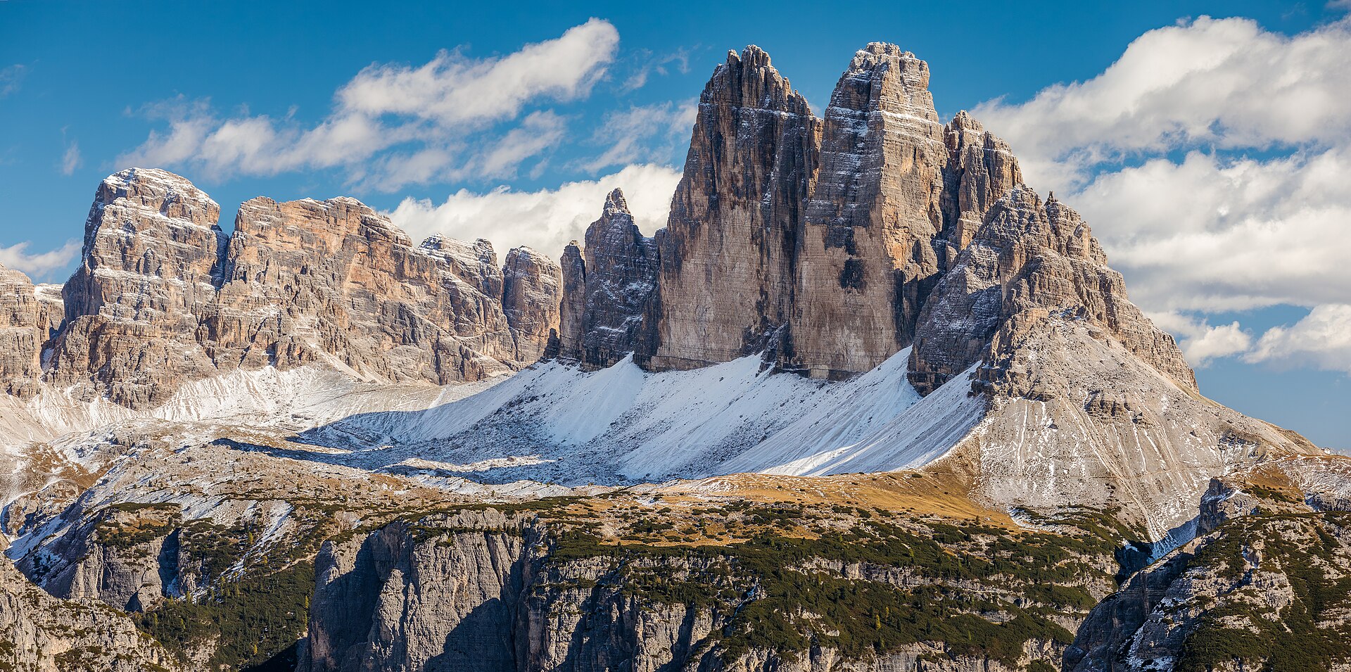
The first time you see Tre Cime di Lavaredo in person, your brain does a small double take. Three vertical slabs of pale rock, lined up like a row of broken teeth, completely out of scale with everything around them.
Here is the short version. To visit Tre Cime di Lavaredo you drive (or bus) up to Rifugio Auronzo, the trailhead at 2,320 m, then walk the roughly 10 km loop around the peaks past Rifugio Lavaredo and Rifugio Locatelli. As of 2026 you must book the toll road online in advance, around €40 per car. Plan four to five hours on the trail.
This guide is for the person who wants to actually pull it off without circling a closed gate or missing the famous view. If you want a wider plan, I link out to the broader Dolomites travel guide and a full Dolomites itinerary below. This page is just about the Three Peaks.
The three ways to reach Tre Cime di Lavaredo
You have three real options to get to the trailhead at Rifugio Auronzo, and the right one depends on whether you have a car, how much you hate crowds, and how flexible your dates are.
| Option | Cost (2026, approx) | Time to trailhead | Best for | The catch |
|---|---|---|---|---|
| Drive + toll road | ~€40/car, ~€26/moto, ~€60/campervan | 10 min from the toll gate | Flexibility, sunrise/sunset, families with gear | Must pre-book online; non-refundable inside 5 days; slots sell out |
| Bus / shuttle | A few euros each way | 20-50 min depending on town | No car, weather insurance, skipping the booking faff | Fixed timetable; seasonal; can fill up |
| Stay overnight at a rifugio | Half-board, book direct | You are already there | Sunrise/sunset without the drive, the full experience | Huts book out months ahead; email only |
Driving is the most common choice and the most flexible. The bus is the underrated one, especially in 2026, and I will explain why. Sleeping at a hut up top is the dark-horse option if you care about light.
Tre Cime parking and the toll road, explained for 2026
Here is the single most important update, and the thing half the older blog posts get wrong: you can no longer just turn up and pay at the gate. The road to Rifugio Auronzo now runs on a mandatory online reservation system run by the Municipality of Auronzo di Cadore. No booking, no entry. Confirm the current rules on the official auronzo.info parking page before you go.
What the toll road actually is
The toll road is a paved panoramic road, about 6 km, that climbs from near Lake Misurina up to the Rifugio Auronzo parking lot at the foot of the south walls. The toll gate sits just past Lago d’Antorno, a couple of kilometres north of Misurina. From the gate it is a 5 km, roughly 10-minute drive to the top.
One ticket covers both the toll and parking. That is the part people miss. You are not paying a toll and then hunting for a separate Tre Cime parking fee. It is one charge for one 12-hour window.
What it costs
As of 2026 the fees run roughly:
- Car: around €40
- Motorbike: around €26
- Campervan / motorhome: around €60
- Bus (up to 30 seats): around €80; larger buses more
These have crept up year over year, so treat them as a guide and check the official site for the exact number before you book. The ticket is valid for 12 hours. Overstay and you can be charged again at the exit booth, and you cannot re-enter once you have left.
How the booking works
You book a date and an entry time (slots typically start around 7:00 a.m. and run into the evening). Here is the bit that confuses everyone: your time slot is just the start of your 12-hour window, not a hard appointment. Book a 7:00 a.m. entry and you can roll up at 9:00 and still be fine. That flexibility matters for sunrise plans and weather.
A few things worth knowing:
- Reservations open about a month ahead. Summer weekends can sell out three to five days in advance. Book early.
- No same-day bookings. You must reserve by late the night before, generally 11:59 p.m.
- Rental car? You can add or edit your licence plate up to the night before, so book first and sort the plate later.
- The plate is your ticket. Cameras read it. No paper to print.
- Cancellation is tight. Free cancellation usually only up to about 5 days before; after that it is non-refundable, and you cannot reschedule, only cancel and rebook.
That non-refundable window is the real trap. The Dolomites make their own weather, and if the forecast turns to fog and rain two days out, you are stuck. Which is exactly why the bus deserves a serious look.
The parking lot itself
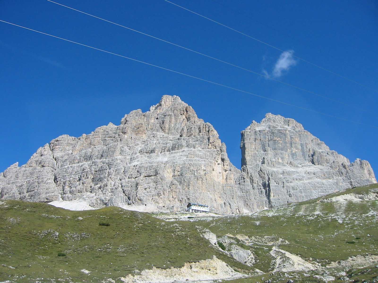
The lot beside Rifugio Auronzo is big, with capacity for several hundred vehicles, but on a clear July Saturday “big” still fills. Because access is now capped by the booking system, the old dawn stampede has eased, but the most popular morning slots still go first. Campervans can pay extra to park overnight in a designated area, which is a sneaky way to catch both sunset and sunrise.
The car-free option: buses from Cortina, Dobbiaco and Misurina
If you do not have a car, or you want a hedge against the non-refundable toll, seasonal buses run right up to Rifugio Auronzo. This is the same trailhead the drivers use, so you lose nothing on the hike itself. For the bigger picture on getting around the range without your own wheels, see my guide to the Dolomites without a car.
Roughly how it shakes out in season (late spring through early autumn, exact dates shift each year):
- From Misurina: DolomitiBus runs the short hop from Misurina up to Rifugio Auronzo in about 20 minutes. This is the quickest link if you are based near the lake.
- From Cortina d’Ampezzo: take a DolomitiBus to Misurina, then connect up to the Rifugio. Budget the better part of an hour and check the transfer. More on the town in my Cortina d’Ampezzo travel guide.
- From Dobbiaco (Toblach): the South Tyrol side runs the Bus 444 “Tre Cime” shuttle from Dobbiaco station, past Lago di Landro, up to Rifugio Auronzo. This one needs to be booked and paid online in advance for the whole season, so do not just show up at the stop.
Two honest caveats. Buses run on a timetable, so an early start and a planned last departure matter, and you do not want to be the person watching the final bus pull away while you are still on the Locatelli terrace. And in peak weeks they fill, so book or arrive early where you can. But at a few euros each way versus €40 and a non-refundable gamble, the bus is the smart play more often than people admit. It also pairs well with arriving by train and bussing the last leg up.
The Tre Cime hike: the classic loop around the Three Peaks
This is the reason you came. The signature Tre Cime hike is the Giro delle Tre Cime, a loop of a bit over 10 km that circles all three peaks and serves up the famous north-face view about a third of the way round.
The numbers
- Distance: ~10 km (about 6.2 miles) round loop
- Time: 4 to 5 hours with stops; you can rush it in 3, but do not
- Elevation change: roughly 350-400 m of up and down
- Difficulty: moderate; mostly wide gravel paths, a couple of genuine climbs
- Surface: compact gravel, loose in places; poles help tired knees
Let me be blunt about the difficulty, because a lot of pages call it “easy” and that gets older or under-prepared hikers into trouble. It is not technical and it is not dangerous, but it is a half-day at 2,300-2,450 m with some real ascents. I have passed plenty of people on the far side of the loop, out of water, racing the daylight, surprised it took so long. Treat it as a proper mountain day and it is a joy.
Which direction to walk the loop
Both directions work. The default, and what most signs assume, is counterclockwise: leave Rifugio Auronzo on trail 101, traverse beneath the south faces to Rifugio Lavaredo, climb to the Forcella Lavaredo saddle for your first head-on view of the north faces, then continue to Rifugio Locatelli for the postcard panorama before looping back across the north side.
Going clockwise (starting toward Malga Langalm on trail 105) is the move when you see a conga line streaming out of the parking lot. You walk against the flow, get the quiet western side to yourself, and still hit every highlight in reverse. The trade-off is you save the most famous view, the one from Locatelli, for the second half rather than the first.
My take: counterclockwise if you start early and want the big reveal up front; clockwise if you arrive mid-morning into crowds and want breathing room.
Walking it counterclockwise, segment by segment
Rifugio Auronzo to Rifugio Lavaredo (~30-45 min). A near-flat traverse on an old military road under the south walls. Look for the boulder with 220-million-year-old dinosaur footprints, and the little Cappella degli Alpini chapel, with Monte Cristallo filling the view behind you. Easy, scenic warm-up.
Rifugio Lavaredo to Forcella Lavaredo (~20-30 min). A short, steeper pull up to the saddle at about 2,450 m. This is the first time the three north faces stand square in front of you, and it is genuinely a jolt. Many people who only want the view, not the full loop, turn around here, and that is a perfectly good half-day.
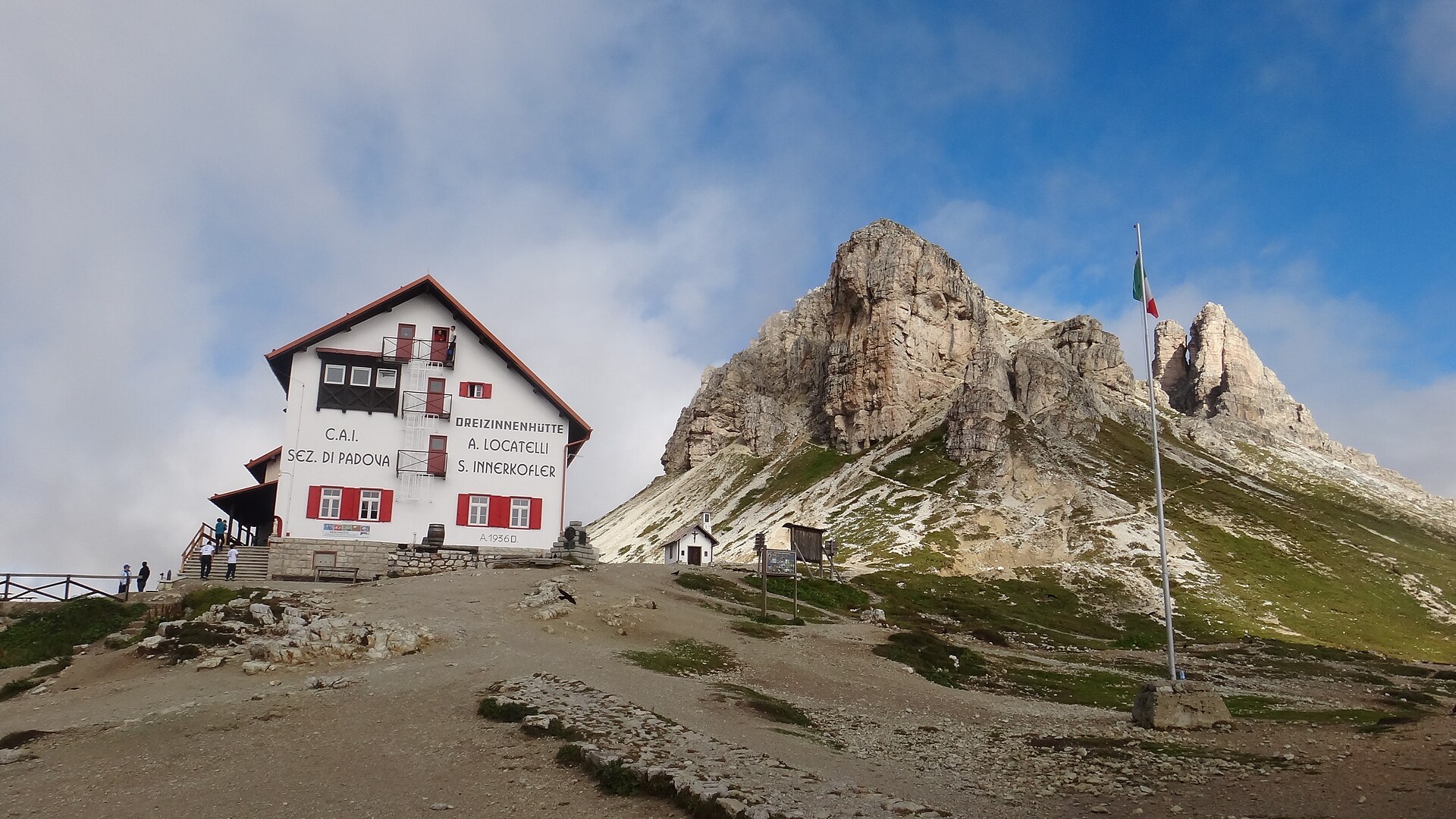
Forcella Lavaredo to Rifugio Locatelli / Dreizinnenhütte (~45-60 min). Descend and cross toward the iconic hut, also called Rifugio Locatelli-Innerkofler, sitting on a plateau facing the north walls. This is the classic shot you have seen a thousand times. Walk a couple of minutes past the crowd, toward the small chapel and the open plateau beyond, for the same view in near silence.
Locatelli back to Rifugio Auronzo (~1.5-2 hr). Follow trail 102 then 105 across the north and west sides past Malga Langalm, where the peaks loom close and the crowds thin, before curving back over Forcella Col di Mezzo to the parking lot. Reward yourself with apple strudel at the Auronzo hut. You earned it.
The rifugi along the way
Three working mountain huts sit on the loop, and they are spaced almost perfectly for a coffee, a meal, or a beer:
- Rifugio Auronzo (2,320 m): the trailhead hut by the parking lot. Big, busy, fine for a start or finish.
- Rifugio Lavaredo (2,344 m): just below the Forcella Lavaredo saddle. A good fuel stop before the climb.
- Rifugio Locatelli / Dreizinnenhütte (2,405 m): the famous one, with the north-face panorama. The view from its terrace is hard to beat.
Carry some cash, since not every hut takes cards, and know that the huts generally only operate from roughly late June to late September. Outside that window the road may be open but the huts shuttered, so pack your own food. For more day-walks across the range once you have done this one, see my roundup of the best hikes in the Dolomites.
Where the iconic view actually is (and the other ones)
People say “the Tre Cime view” as if there is one. There are several, and they look like different mountains.
- The north faces — the postcard, the three sheer parallel towers — are seen from the Forcella Lavaredo saddle and Rifugio Locatelli, on the far side of the loop. This is the view, and you have to walk to it. There is no driving to this one.
- The south faces are what you see from the road and the parking lot. Still huge, but a chunkier, more buttressed profile.
- Lago d’Antorno, the small lake on the toll road, gives a lovely shot of the south faces reflected in water. Stop here on the drive up or down.
- Lago di Misurina, the bigger lake just below, offers a wider, more distant framing, ideal after the hike. It is one of the prettiest pull-offs in the area.
So if your one goal is the famous image, understand that it lives on the north side and requires the hike (or at least the walk to Forcella Lavaredo). You cannot shortcut to it by car.
Sunrise, sunset and the best time to go
The Three Peaks face roughly north on their famous side, which changes the light game.
Sunrise lights the north faces beautifully and the crowds are thinnest, but you need to either sleep at a hut up top or be on an early entry and walking in the dark to reach Locatelli for first light. It is a commitment. The payoff is the mountain almost to yourself.
Sunset is the easier win. Stay until the south and west faces catch the warm light, and the parking lot empties out. If you are in a campervan paying to park overnight, you get both ends.
Season: the road and huts run roughly late May/June to October, all weather-dependent. For fewer people and golden larches, mid-September to mid-October is my favourite window, with the caveat that huts start closing late September and weather gets moodier. High summer, June to early September, is reliable but busy. For the bigger seasonal picture, see best time to visit Italy, and specifically Italy in September and Italy in October, which is when the Dolomites are at their best.
Time of day: the old advice was “arrive by 7 a.m. for parking.” The booking system has softened that, but mornings are still the busiest. A genuinely good 2026 tactic is to take an afternoon entry: arrive around or after midday as the early crowd leaves, and you often get a quieter trail and lovely late light. Just keep an eye on hut closing times and the last bus.
How to fit Tre Cime into a Dolomites trip
Tre Cime is a half-day to full-day outing, not a base in itself. Most people slot it into a wider Dolomites loop. I would not build the whole trip around it, but I would not skip it either.
The natural bases are Cortina d’Ampezzo (Veneto side, closest big town), Dobbiaco / Toblach, Misurina (right at the foot, tiny), or anywhere in the Alta Pusteria valley. From Val Gardena it is a longer day trip but doable; see the Val Gardena travel guide. For where to base yourself and book beds, I have a dedicated where to stay in the Dolomites guide.
If you are routing the wider region, build the days out with a full Dolomites itinerary. Driving the mountain roads is half the fun but takes nerve; read renting and driving a car in Italy first. And come autumn, the same peaks turn into a winter playground, covered in Italian Alps in winter.
What to bring
Nothing exotic, but the mountain punishes the under-packed:
- Layers and a windproof jacket. It can be warm in the lot and cold at the saddle within the hour.
- Proper footwear. Trail runners are fine for the fit; boots if your ankles want support on loose gravel.
- Water and snacks. At least a litre. Do not count on a hut being open or quiet.
- Sun protection. You are high; the sun bites even when it is cool.
- Cash. For huts that do not take cards.
- Poles, if your knees dislike long descents on gravel.
For the full kit rundown across a trip, see my Italy packing list.
Final thoughts
Tre Cime di Lavaredo earns the hype, which is rare. Sort the booking, pick your direction, give it the whole half-day it deserves, and walk far enough to see the north faces, because that is the view that stays with you. If you are still shaping the wider trip, start with the Dolomites travel guide and the Italy travel tips page, then come back here when your dates are set.
Questions travellers ask
Do I need to book parking for Tre Cime di Lavaredo in advance?
Yes. As of 2026, driving the toll road up to Rifugio Auronzo requires an online reservation made by the night before, no same-day bookings. Your plate acts as the ticket. Reservations open about a month ahead and popular summer slots sell out days early, so book as soon as your dates are firm.
How much does it cost to drive up to Tre Cime?
Around €40 per car as of 2026, with motorbikes near €26 and campervans near €60. One payment covers both the toll road and 12 hours of parking at Rifugio Auronzo. Fees rise most years, so confirm the exact amount on the official auronzo.info booking page before you reserve your slot.
How long is the Tre Cime di Lavaredo loop hike?
The classic loop is a little over 10 km (about 6.2 miles) and takes most people four to five hours with photo and food stops. Elevation change is modest, roughly 350-400 m, but there are a couple of real climbs. It is moderate, not easy, so give it most of a day.
Can you visit Tre Cime without a car?
Yes. Seasonal buses run to Rifugio Auronzo from Misurina, Cortina d’Ampezzo and Dobbiaco. The Dobbiaco shuttle (Bus 444) must be booked online in advance. Buses run on a timetable and can fill in peak weeks, so plan your first and last departures, but it is far cheaper than the toll.
What is the best time of day to hike Tre Cime di Lavaredo?
Early morning is least crowded but most people aim for it, so the trail and lot get busy from mid-morning. A good alternative is arriving in the early afternoon as the morning crowd leaves, which often means a quieter trail and nicer light. Just watch hut closing times and the last bus.
When does the Tre Cime toll road open and close?
Roughly late May or early June until late October or early November, entirely dependent on snow and ice. Heavy snow years can push the opening to late June. In autumn the road may only open during daylight hours for safety. Always check the official site or Auronzo tourist office close to your date.
Where is the famous view of the three peaks?
The iconic shot of the three parallel north faces is seen from the Forcella Lavaredo saddle and Rifugio Locatelli, on the far side of the loop, reachable only on foot. The view from the road and parking lot shows the chunkier south faces. To get the postcard, you have to do at least part of the hike.
Can you stay overnight at Tre Cime di Lavaredo?
Yes. Three rifugi on the loop offer beds: Rifugio Auronzo, Rifugio Lavaredo and Rifugio Locatelli. They open roughly late June to late September, book up months ahead, and usually take reservations only by email or phone. Staying up top is the best way to catch sunrise or sunset without the drive.